


Salt Flat Lakes: Today’s Playas are Remnants of Vast Ice-Age Waters
By Andrew Stuart
A rainy summer has brought a special beauty to all of West Texas. But Linda Lakes – the salt playas beneath the Guadalupe Mountains – have been the season’s stars. The lakes are shallow and short-lived, but they shine like turquoise – and, in still hours, reflect the mountains above. It’s not the first time they’ve filled in recent years – but it is a first in the age of Instagram, and social media introduced a large audience to this sublime scene from remote West Texas.
And there’s a story here that even most longtime West Texans don’t know. Today’s lakes are the remnants, the descendants, of a much larger body of water. “Lake King” once covered 350 square-miles, and was 85 feet deep. Its ancient bed is visible from space.
In the 1990s, geologist David Wilkins set out to trace its history. What he found draws us into another world.
“It would have been a pretty cool time to be around,” Wilkins said.
Imagining Ice-Age West Texas – picturing mammoths and camels watering at a vast lake, beneath a snow-capped Guadalupe Peak – it’s hard to argue with Wilkins.
In their studies of the West, geologists fairly quickly understood that the arid region had once looked quite different. In 1890, G.K. Gilbert published a study of “Lake Bonneville,” which covered 20,000 square-miles in present-day Utah, Nevada and Idaho. The Bonneville Salt Flats – the setting for countless car ads – are the lake’s bed. Ancient lakes were later identified across the West, including Lake Lahontan, in the Great Basin, and Lake Estancia, in central New Mexico.
A San Antonio native, and professor at Boise State University, Wilkins’ initial focus as a PhD student was the Salt Basin dunes, near the Guadalupes. But he was joined on a dunes trip by Don Currey, his adviser, and an expert on “paleolakes.”
“When Don and I drove out into the basin for the fist time,” Wilkins said, “coming from El Paso, his eyes were tuned-in better to lake stuff than mine were, in my second year of doctoral studies, and he started identifying: ‘Here’s a shoreline, here’s a shoreline, here’s another shoreline.’ So my focus shifted, or expanded.”
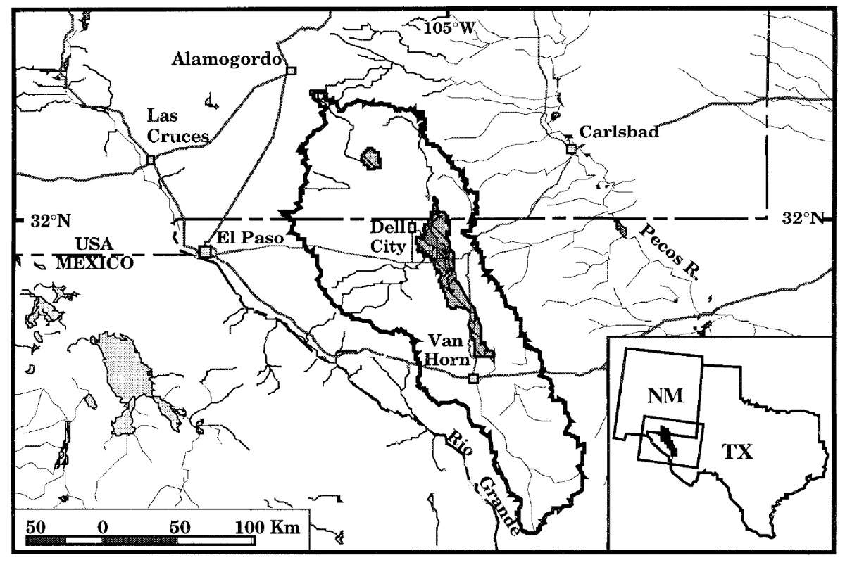
Like a small version of the Great Basin, a large part of our region – from just west of Marfa to Sacramento Peak, near Alamogordo – is “hydrographically” closed. Water stays in the basin – there’s no outflow to the Rio Grande or Pecos. In 1948, geologist P.B. King was the first to conclude that this area – the Salt Basin – had contained an Ice-Age lake.
Little was known of its extent or age before Wilkins and Currey’s work. The two were granted access to private land, and at sites around the basin found remnants of three prominent shorelines. There were beach gravels and ridges. Aerial photos revealed “spits” – promontories built by lake currents.
Some of the shoreline features are 75 feet above the present desert floor. At its greatest “highstand,” Wilkins concluded, Lake King stretched from what’s now the New Mexico state line almost to Van Horn.
Wilkins set out to date the lake’s highstands. In “freshening” events, Lake King filled so quickly that plants on the lake bed were drowned and preserved. Wilkins excavated some of these rank and rotting deposits, and conducted radiocarbon dating.
It yielded three date ranges – which Wilkins correlated with the three shorelines. Lake King’s first and greatest highstand occurred more than 22,000 years ago. The last highstand was 5,000 years later. In each episode, high lake levels probably only lasted a matter of decades, Wilkins said.
“It doesn’t take long, at a highstand, to have a pretty prominent beach ridge,” he said. “Bonneville, they estimate, was at its highest highstand for maybe only 30 or 40 years, but it was able to leave some pretty prominent features there.”
Wilkins explored another lake in the basin – 45 miles northwest of Lake King. Lake Sacramento, at the base of the Sacramento Mountains, was small, but deep. And through underground fractures and fissures, its waters seeped south to Lake King.
“My analogy was akin to a leaky toilet,” Wilkins said. “Here’s your toilet tank. It’s constantly running, no matter how much you jiggle it, and you have the water seeping to the bowl down below.”
That “leaky toilet” remains important. Snowmelt and rain in the Sacramento Mountains still make their way to the Salt Basin in the form of groundwater. That groundwater has sustained farming in Dell City for decades – and in recent years, the City of El Paso used $200 million in taxpayer-backed loans to acquire land in Dell City, with a plan to import the groundwater for municipal use.
As with other vanished lakes in the West, Lake King was a feature of what’s known as the “Last Glacial Maximum.” The action of glaciers and ice sheets altered fundamental dynamics in the Earth’s atmosphere. The jet stream, North America’s storm track, was pushed to the south, bringing cooler, wetter conditions. The mean annual temperature here was 18 degrees lower than today. There was permafrost in the Guadalupes.
It’s hard to imagine. But Lake King is a reminder – that as timeless as it seems, this land has seen many changes. There are certainly more to come.
Nature Notes is supported by the Shield-Ayres Foundation and produced by Marfa Public Radio with the Sibley Nature Center. The program can be heard each Tuesday and Thursday, at 7:45 a.m. and 4:45 p.m., Central time, on KRTS Marfa, 93.5 FM, and KXWT Odessa/Midland, 91.3 FM. This episode was written by Andrew Stuart.


